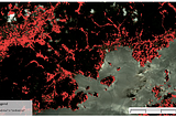
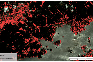
Glenn KongAnalysing the Impact of Natural Hazards with Remote Sensing TechniquesThis article delves into the use of remote sensing techniques to assess the impact of natural hazards on landscapes.Feb 3, 2024Feb 3, 2024
Glenn KongExplore Distance-decay Relationship with PythonModern geographers and urban planners frequently utilise spatial analysis to understand how human activities and land uses are dispersed…Oct 5, 2023Oct 5, 2023
Glenn KongGIS/Geospatial Master Programs in AustraliaIn today’s fast-paced world, the value of postgraduate education continues to rise. For many, it’s not just about gaining deeper knowledge…Sep 25, 2023Sep 25, 2023
Glenn KongHow Real-time Web-based GIS Helps Build the Smart Cities of the FutureThe concept of “smart cities” has gained global recognition as the leading vision for future urban development. In this context, the…Jul 13, 2023Jul 13, 2023
Glenn KongList of Geospatial Companies in TaiwanIn this ever-evolving age of technology, Geographic Information Science (GIS) plays a vital role across various industries. From urban…Jun 1, 2023Jun 1, 2023
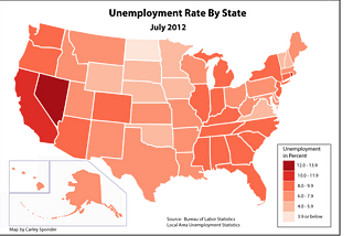
Glenn KongNever Ever Do in a Choropleth Map!A choropleth map is a great tool to show data in a thematic way, using shaded or patterned areas in proportion to a statistical variable…Jun 2, 2020Jun 2, 2020
InMapxusbyGlenn KongFrom Ground Level to the Top Floor: An Indoor Solution to Europe’s Growing SkyscrapersIf you have ever been to Europe or had the chance to explore the continent, you may have noticed that European cities have a very different…Apr 20, 2023Apr 20, 2023
Glenn KongGlobal Top 50 Universities for Master’s in GISWant to pursue a graduate degree in GIS? This article lists the top 50 universities in the world with GIS master’s programs.Apr 26, 20233Apr 26, 20233